EMSC Week 11 - A detailed look at the depth-age relationship for the seafloor.#
We are going to work with the ETOPO1 dataset (Amante et al) which we can download from various services online when we need it. You can read more about the dataset here: https://ngdc.noaa.gov/mgg/global/
We need some libraries to help with downloading, manipulating and plotting the data:
numpyto manipulate arraysxarraywhich extendsnumpyfor data that might be too big to read all at oncematplotlibandcartopyfor plotting data on maps
Navigation#
References#
Amante, C. “ETOPO1 1 Arc-Minute Global Relief Model: Procedures, Data Sources and Analysis.” National Geophysical Data Center, NOAA, 2009. https://doi.org/10.7289/V5C8276M.
Read ETOPO data from a remote service#
This is how we access the data - provide a url, open that url, and ask for a subset of the data (either by region or by taking every n’th value)
    etopo_dataset = "http://thredds.socib.es/thredds/dodsC/ancillary_data/bathymetry/ETOPO1_Bed_g_gmt4.nc"
    etopo_data = xarray.open_dataset(etopo_dataset)
    subs_data = etopo_data.sel(x=slice(left,right, 30), y=slice(bottom, top, 30))
Here we have requested every 30th data point.
(left, bottom, right, top) = (-180, -90, 180, 90)
map_extent = ( left, right, bottom, top)


etopo_dataset = "dap2://thredds.socib.es/thredds/dodsC/ancillary_data/bathymetry/etopo2.nc"
etopo_data = xarray.open_dataset(etopo_dataset, engine="pydap")

# Take every 180th point of the 1 arc minute dataset (in each axis)
subs_data = etopo_data.sel(lon=slice(left,right, 30), lat=slice(bottom, top, 30))

lons = subs_data.coords.get('lon')
lats = subs_data.coords.get('lat')
vals = subs_data['topo']

x,y = np.meshgrid(lons.data, lats.data)
height = vals.data
Metadata#
We might need to know more about the dataset before we know how to work with it. Data about data is known as metadata and that’s what we need.
etopo_data.info()
Validation#
Can you check to see what resolution data we have downloaded ?
(hint the height data is a numpy array and has a shape attribute)
Check here:
print("The shape of the array is ... ")
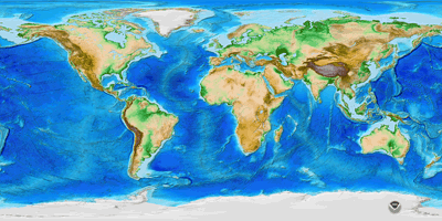
and we should plot the data to see if it matches the image above and whether we need more resolution. Does that look right ?
If the map is horribly pixelated, we might try downloading more data. Don’t go mad or it will take forever.
import cartopy.crs as ccrs
import cartopy.feature as cfeature

coastline = cfeature.NaturalEarthFeature('physical', 'coastline', '10m',
                           edgecolor=(1.0,0.8,0.0),
                           facecolor="none")

plt.figure(figsize=(15, 10))
ax = plt.subplot(111, projection=ccrs.PlateCarree())
ax.set_extent(map_extent)

ax.add_feature(coastline, edgecolor="black", linewidth=0.5, zorder=3)

plt.imshow(height, extent=map_extent, transform=ccrs.PlateCarree(),
           cmap='terrain',  vmin=-5000., vmax=5000.)
The map does not look quite right, does it ?
It is important to check the data that you download to make sure that:
you downloaded the correct data
the resolution is enough for the job at hand
the dataset is complete / not corrupted
In the map, the data is obviously not exactly as we would expect. It’s obviously not corrupted but it is not correctly formatted for the imshow command. You can fix this in one of two ways: either adjust the ordering of the dataset to match what imshow wants or ask imshow to do it for you by adding the origin="lower" argument.
## Fixed code here
Exercise#
Download the data at high(er) resolution and make a nicer map (say skip every 30 instead of 300) that’s \(10 \times 10\) more data points so it might take a bit longer to download / plot.
Note: the purpose of this exercise is to show you some very basic ways to check the data by downloading a small sample before launching into an expensive analysis.
# This is how you save it if you want to keep it
# fig.savefig("ETOPO1.png", dpi=150)