# EMSC 3002 ## Module 1.1 - Global Deformation Patterns - **Louis Moresi** (convenor) - Chengxin Jiang (lecturer) - Romain Beucher (former lecturer) - Stephen Cox (curriculum advisor) Australian National University _**NB:** the course materials provided by the authors are open source under a creative commons licence. We acknowledge the contribution of the community in providing other materials and we endeavour to provide the correct attribution and citation. Please contact louis.moresi@anu.edu.au for updates and corrections._ <--o--> ## Plate Tectonics <center> 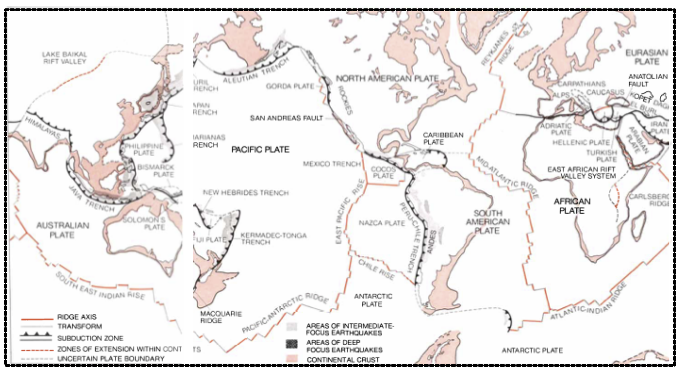 <!-- .element style="width:66%;" --> </center> This part of the course introduces the concepts of global-scale tectonics, plate motions, the nature of plate boundaries and the geological structures characteristic of large-scale deformation of the crust. <br> <small> *Dewey, J. F. (1972). PLATE TECTONICS. Scientific American, 226(5), 56–72. https://doi.org/10.1038/scientificamerican0572-56 - a global map of the "Mosaic of Plates [that] forms the Earth's lithosphere or outer shell"* </small> <--o--> ## Plate Tectonics (Wikipedia)  <!-- .element style="float:right; width:30%"--> Plate tectonics is a scientific theory describing the large-scale motion of the plates making up the Earth's lithosphere since tectonic processes began on Earth *between 3.3 and 3.5 billion years ago*. The model builds on the concept of continental drift, an idea developed during the first decades of the 20th century. The geoscientific community accepted plate-tectonic theory after seafloor spreading was validated in the late 1950s and early 1960s. The lithosphere, which is the rigid outermost shell of a planet (the crust and upper mantle), is broken into tectonic plates. The Earth's lithosphere is composed of seven or eight major plates (depending on how they are defined) and many minor plates. Where the plates meet, their relative motion determines the type of boundary: convergent, divergent, or transform. Earthquakes, volcanic activity, mountain-building, and oceanic trench formation occur along these plate boundaries (or faults). The relative movement of the plates typically ranges from zero to 100 mm annually. <--o--> ## Learning Outcomes for this module What you will learn about global tectonics. - The global datasets that we use to understand tectonic processes - The relationship between plate motions and plate boundary structures - The difference between continental and oceanic deformation - How mantle convection drives the plates - Background on stresses, strains, rheology - Background on deformation style and observations <--o--> ## The Earth in Cross Section <div style="width:30%; float:right">  </div> <div style="width:70%"> This image is drawn approximately to scale - The **core** is roughly 1/2 the radius (1/8 volume) and the **inner core** is roughly 1/2 the radius of the core </br> - Most of the Earth (by volume) is the mantle - the *lower mantle* is below 670km </br> - The **oceanic lithosphere** is no more than about 100-150km thick and the **continental lithosphere** can be up to 400km (maybe) thick in cratonic areas </br> - The **continental crust** is a few tens of km thick (exaggerated in the diagram) but the **oceanic crust** is nearly always about 6-7 km thick ... too thin to show ! </div> <--v--> ## The Earth in Cross Section <div style="width:30%; float:right">  </div> <div style="width:70%"> The circulation currents in the *solid mantle* move at a few cm/yr and plate motions are part of the overall circulation. Mantle Plumes are also part of the overall circulation but much smaller than the slabs because they are cylindrical rather than sheets. Flow in the mantle is broad scale - small structures induce broad flow. On a global scale, movement is slow and viscous, especially in the deep mantle. </div> <--o--> ## Thickness of the Lithosphere  <!-- .element style="display:block; margin-left:auto; margin-right:auto; width:60%" --> This map shows the lithospheric thickness coloured as though it refers to temperature (thin lithosphere is in warm colours, thick is in cool colours) which does have some physical relevance. The greyscale is topography. <--v--> ## Thickness of the Continental Lithosphere  <!-- .element style="display:block; margin-left:auto; margin-right:auto; width:60%" --> A similar map that *contours* the thickest parts of the lithosphere (scale is in km) and leaves out the oceans altogether. <--v--> ## Relative thickness of Crust and Lithosphere  <!-- .element style="display:block; margin-left:auto; margin-right:auto; width:60%" --> This map shows the relative thickness of the crust and the lithosphere (thick crust is dark). You can immediately see how important the mechanical structure of the lithosphere is when it comes to the response to geological stresses. *The coloured dots are earthquake hypocentres coloured by depth and mostly show where the slabs are located.* <--o--> ## Global Stress  <!-- .element style="float:right; margin-top:50px;margin-bottom:50px; width:50%; margin-left:50px" --> The World Stress Map (WSM) 2016 displays the contemporary crustal stress orientation in the upper 40 km based on the WSM database release 2016. Lines show the orientation of maximum horizontal stress. The colours indicate whether stresses are: - Normal faulting - Strike slip - Thrust faulting So, already, we can see that the state of stress and deformation style are closely linked. Note that the **magnitude** of the stress is not part of this map. <--v--> ## Australian Stress field  <!-- .element margin-top:50px;margin-bottom:50px; width:50%; margin-left:50px" --> Close up of the World Stress Map, focussing on the data in Australia. Note that many areas are completely unconstrained by observations in this map. <--v--> ## Australian Stress field - Trajectories  <!-- .element margin-top:50px;margin-bottom:50px; width:50%; margin-left:50px" --> The "stress-trajectories" for Australia (left) that show the "flow lines" of the compressional stress direction. These interpolate the actual data in a smooth fashion. On the right, a computational model of the stress field based on plate boundary forces and mantle drag forces. <--v--> ## Global Seismicity The magnitude of the stress is related to the rate of seismic energy release because this is a measure of those places which are under enough stress for the lithosphere to "break". <center> <video autoplay controls width="75%"> <source src="movies/GlobalEQCumulative.m4v" type="video/mp4"> Sorry, your browser doesn't support embedded videos. </video> </center> Usually this takes the form of a fault that already exists sliding because the shear stresses are large compared to the confining pressure. <--v--> ## Global Strain rate <center>  <!-- .element style="float:right; margin-top:50px;margin-bottom:50px; width:50%; margin-left:50px" --> <!-- .element stoyle="width:60%" --> </center> The strain rate is a measure of how fast deformation is taking place. Strain rate is a measure of the rate of change of length (units are $s^{-1}$) *and* it is a tensor: there are multiple components that represent normal and shear strains. The measure shown here is an average (the second invariant). The rate of deformation is related to two things: the stress applied and the strength of the material. <small> Kreemer, C., Blewitt, G., & Klein, E. C. (2014). A geodetic plate motion and Global Strain Rate Model. Geochemistry, Geophysics, Geosystems, 15(10), 3849–3889. https://doi.org/10/f6p92p </small> <--v--> ## Global Volcanism <center>  <!-- .element style="width:60%" --> </center> Volcanic activity is distributed similarly to that of seismicity and mostly occurs at convergent and divergent plate boundaries. There is also a significant level of intra-plate volcanism. Magma pathways within the crust are influenced by the stress field and we can analyse volcanic structures to determine the ambient stress field at the time they were formed. <small> Make your own map from the NOAA natural hazards interactive web page: [https://maps.ngdc.noaa.gov/viewers/hazards](https://maps.ngdc.noaa.gov/viewers/hazards/?layers=3) </small> <--o--> ## Plate Tectonics (Wikipedia + annotation)  <!-- .element style="float:right; width:30%"--> Plate tectonics is a scientific theory describing the large-scale motion of the plates making up the Earth's lithosphere since tectonic processes began on Earth *between 3.3 and 3.5 billion years ago*. The model builds on the concept of continental drift, an idea developed during the first decades of the 20th century. The geoscientific community accepted plate-tectonic theory after seafloor spreading was validated in the late 1950s and early 1960s. The lithosphere, which is the rigid outermost shell of a planet (the crust and upper mantle), is broken into tectonic plates. The Earth's lithosphere is composed of seven or eight major plates (depending on how they are defined) and many minor plates. Where the plates meet, their relative motion determines the type of boundary: convergent, divergent, or transform. Earthquakes, volcanic activity, mountain-building, and oceanic trench formation occur along these plate boundaries (or faults). The relative movement of the plates typically ranges from *zero to 100 mm annually*. <--o--> ## Discussion points 1. How can we measure plate motions (now, in the past ?) 1. Does plate tectonics really apply to the continents ? 1. What is the most obvious difference between the response of continental crust and oceanic to mantle forcing ? We will revisit these questions throughout the course. <--o--> ## Global Plate Motions  <!-- .element style="width:60%; float:right;" --> <div> This map is the plate motions derived from the NUVEL-1 model in a No-Net-Rotation frame of reference in which the major contienental masses do not move very much. 1. We only measure the relative motion of plates relative to one another. 2. The speed of the plates can vary even though they are rigid because their motion is described by their **angular velocity** about a pole (Euler pole). </div> <small> You can build your own global dataset of plate motions from a UNAVCO website here: [https://www.unavco.org/software/geodetic-utilities/plate-motion-calculator/plate-motion-calculator.html](https://www.unavco.org/software/geodetic-utilities/plate-motion-calculator/plate-motion-calculator.html) and also read more about the models / data themselves. </small> <--o--> ## Plate Boundaries The regions of highest strain rate at the surface of the Earth are the plate boundaries. <center>  <!-- .element style="width:66%;" --> </center> The styles and patterns of deformation are very dependent on the orientation of the stresses that are acting at the boundary. <--o--> ## Plate Boundaries <center>  <!-- .element style="width:66%;" --> </center> This map includes diagrams of the physical processes that are happening at the smaller scale at each type of plate boundary. <small> World Map of Plate Boundaries, Bonnie Magura (Portland Public Schools) and Chris Hedeen (Oregon City High School) from https://serc.carleton.edu/ANGLE/educational_materials/activities/204690.html </small> <--o--> ## Take away points Do you know the answers to these questions ? - Is the mantle solid or liquid ? </br> - What is the relationship between crust and lithosphere ? </br> - How fast do the plates move (typically / roughly) ? </br> - What evidence do we have that plates are "rigid" ? </br> - Is plate tectonics really a theory about plates ? <--o-->