Introduction#
This course teaches the concepts of structural geology and tectonics using examples from the unique geological history of the Australian plate and its boundaries. It develops a broad understanding of the processes that shape the continental crust and the forces that drive geological deformation. Basic principles of rock mechanics at scales ranging from a single crystal to continental-wide give a quantitative understanding of the connection between stress and deformation. The course connects geological mapping to geophysical imaging to provide the essential tools for understanding how, when and why structures form in the crust and how they relate to the formation of important mineral deposits, sedimentary basins, fault systems and their associated earthquakes. There are opportunities to undertake mapping exercises in the field or with digital geology tools, as well as an introduction to laboratory analogue experiments and computational models.
What you will learn from this course#
Upon successful completion, students will have the knowledge and skills to:
Describe the broad geological history of the Australian plate and place its major structures in their tectonic context.
Explain the relationship between plate kinematics, plate tectonics forces and the deformation patterns in the continental crust.
Evaluate how observational data collected during laboratory experiments and field work (in person or virtual) supports or refutes theoretical concepts in structural geological and tectonics.
Predict the geometry and location of structures at depth or in areas of poor outcrop through the use of geological and geophysical observations.
Interpret the relative timing of formation of structures, the kinematics of deformation, and progressive deformation histories in geological settings and laboratory / computer analogues.
Synthesise field observations and theoretical / laboratory-derived concepts to interpret a geological cross section within its tectonic context.
Independently develop laboratory analogue experiments that represent archetypal geological structures.
For HPO students only: Integrate computational modelling results or independent literature review with advanced concepts in tectonics/structure.
Course Themes#
The broad themes of the course and these materials can be broken down as follows
Lecture 1 - Introduction and expectations#
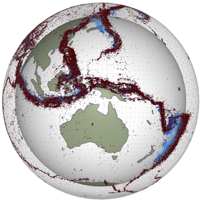
Module i - Global Tectonics#
Introduces the concepts of global-scale tectonics, plate motions, the nature of plate boundaries and the geological structures characteristic of large-scale deformation of the crust.
Module ii - Structures in the Earth#
This module aims to develop student intuition and proficiency in 3- and 4-dimensional visualization and thinking and teach the fundamentals of rock deformation using natural examples.
You will be given an overview of the geometry and type of structures produced by complex crustal deformation histories involving contractional, extensional and wrench regimes over a wide range of spatial and temporal scales. You will learn how to recognise structural features using satellite imagery, geological maps and will learn how to construct geological profiles.
Module iii - Theoretical Underpinnings#
In order to understand geological structures in more detail, we need some background understanding of how stresses and strains work, how they are measured, and how you can use these concepts to interpret what you see in the field.
Module iv - Brittle Deformation#
When rocks undergo rapid, localised deformation, refer to the process as “brittle deformation”. Typically brittle features in the Earth’s crust are faults and we can understand much about the stress and deformation if we understand faults, their rupture and associated seismic energy release.
Module v - Ductile Deformation#
Ductile deformation occurs when rocks are able to accommodate large deformations without fracturing. You will learn how to recognise elements of ductile deformation such as folding, shearing and stretching.
We will see how folds represent important windows into local and regional deformation histories. You will learn how to describe geometry and different styles of folding and will understand how we can use them to derive important information about the type of deformation. You will then learn about structures associated with folding and see how they can be used to map and understand the deformation history.
We will first look at the geometric aspects of folds then will pay attention to the mechanisms at work during folding of rock layers.
We will then look at the relationships with other structural features such as cleavages, lineations, shistosities, boudinages and how we can retrieve kinematic and paleostress information from them.
We will look at the formation of shear zones and will learn how to recognise important kinematic indicators.